In a groundbreaking study that promises to revolutionize urban environmental monitoring, researchers at the Massachusetts Institute of Technology (MIT) have unveiled a novel method for generating near real-time, high-resolution maps of vehicular emissions within cities. Leveraging existing sensor networks and vast amounts of mobile data, this innovative approach offers an unprecedented granular view of pollution, paving the way for more targeted and effective local transportation and decarbonization policies. The findings, published in the prestigious journal Nature Sustainability, detail a framework that significantly surpasses the capabilities of traditional emission assessment methods.
A New Era of Urban Emission Mapping
The conventional approaches to understanding vehicle emissions often rely on intermittent sampling or broad citywide inventories, which lack the precision needed to inform nuanced policy decisions. These methods can miss critical localized hotspots and the dynamic fluctuations in pollution caused by daily traffic patterns. The MIT research, however, introduces a paradigm shift by integrating multiple data streams to extrapolate highly detailed emission maps, capable of identifying pollution levels down to individual roads and even specific hours of the day.
"Our model, by combining real-time traffic cameras with multiple data sources, allows extrapolating very detailed emission maps, down to a single road and hour of the day," explains Paolo Santi, a principal research scientist at the MIT Senseable City Lab and co-author of the study. "Such detailed information can prove very helpful to support decision-making and understand effects of traffic and mobility interventions." This level of detail was previously unattainable, bridging the gap between broad, less informative citywide inventories and labor-intensive, small-scale analyses of individual vehicles.
Carlo Ratti, director of the MIT Senseable City Lab, emphasized the significance of this development within the lab’s broader mission. "This research is part of our lab’s ongoing quest into hyperlocal measurements of air quality and other environmental factors," Ratti stated. "By integrating multiple streams of data, we can reach a level of precision that was unthinkable just a few years ago – giving policymakers powerful new tools to understand and protect human health."
Harnessing Existing Infrastructure and Protecting Privacy
A key strength of the MIT methodology lies in its cost-effectiveness and scalability, as it primarily utilizes infrastructure already in place. The study leverages computer vision techniques applied to images from traffic cameras, combined with anonymized location data from millions of mobile phones. Crucially, this integration is designed to safeguard individual privacy. The computer vision algorithms are trained to recognize vehicle types without compiling license plate numbers or other personally identifiable information.
"The very basic idea is just to estimate traffic emissions using existing data sources in a cost-effective way," notes Songhua Hu, a former postdoc at the Senseable City Lab and now an assistant professor at City University of Hong Kong, who led much of the research. This pragmatic approach ensures that the technology can be widely adopted by municipalities without requiring substantial new investments in specialized sensor equipment.
The research paper, titled "Ubiquitous Data-driven Framework for Traffic Emission Estimation and Policy Evaluation," was authored by Hu; Santi; Tom Benson, a researcher at the Senseable City Lab; Xuesong Zhou, a professor of transportation engineering at Arizona State University; An Wang, an assistant professor at Hong Kong Polytechnic University; Ashutosh Kumar, a visiting doctoral student at the Senseable City Lab; and Ratti. The MIT Senseable City Lab is an integral part of MIT’s Department of Urban Studies and Planning.
Manhattan: A Real-World Proving Ground
To validate their framework, the researchers focused their efforts on Manhattan, New York City, a densely populated and highly trafficked urban environment. The study utilized images from 331 traffic cameras strategically located at intersections across the borough. These visual data were augmented by anonymized location records from over 1.75 million mobile phones.
Through sophisticated vehicle-recognition programs, the team was able to categorize 12 broad types of automobiles, achieving an impressive 93 percent accuracy in classifying vehicles. This granular categorization is vital, as different vehicle types have distinct emission profiles. Furthermore, the camera data provided invaluable insights into how traffic signal operations influence traffic flow. This is a critical factor, as the stop-and-go patterns induced by traffic lights are significant contributors to urban emissions, yet are often overlooked in less detailed conventional inventories.
The mobile phone data then provided a comprehensive overview of traffic dynamics across the city, detailing overall movement patterns and the trajectories of individual vehicles. By combining this rich spatial and temporal information with established emission rate data for different vehicle types, the researchers were able to construct highly accurate emissions estimates for Manhattan.
"We just need to input all emission-related information based on existing urban data sources, and we can estimate the traffic emissions," Hu explained, highlighting the model’s reliance on readily available urban data.
Simulating Policy Impacts and Uncovering Hidden Truths
Beyond mere estimation, the MIT framework possesses a powerful predictive capability. The researchers demonstrated its utility by evaluating the potential emission changes under various hypothetical scenarios, such as alterations in traffic patterns or shifts in vehicle composition.
One simulation explored the impact of reallocating travel demand from private vehicles to public transportation. Another scenario examined the effect of spreading out morning and evening rush hour periods, thereby reducing the peak concentration of vehicles on the road. These simulations underscore the model’s ability to project the consequences of policy interventions before they are implemented.
A particularly insightful aspect of the research involved comparing the accuracy of the detailed model against simplified approaches. The team modeled the effects of replacing fine-grained emissions inputs with citywide averages. The results were stark: these rougher estimates could vary widely, deviating from the more fine-tuned results by as much as -49 percent to +25 percent. This finding serves as a critical warning about the potential for significant errors to be introduced into emission estimations through oversimplification.
Congestion Pricing: A Real-World Impact Assessment
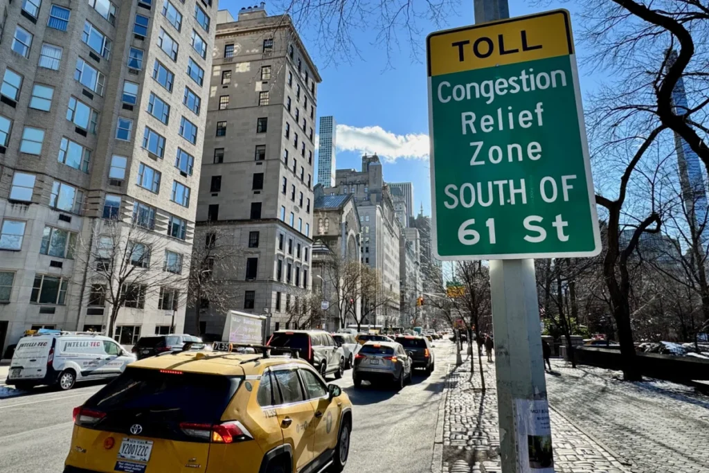
The study also seized upon a significant real-world policy change: the implementation of congestion pricing south of 60th Street in Manhattan, which took effect in January 2025. The MIT researchers meticulously analyzed vehicle traffic data at two, four, six, and eight-week intervals following the program’s inception.
Their analysis revealed that congestion pricing led to an approximate 10 percent reduction in overall traffic volume. More remarkably, this decrease in traffic was accompanied by a substantial drop in emissions, ranging from 16 to 22 percent. This finding aligns with independent research, such as a study by Cornell University researchers that reported a 22 percent reduction in particulate matter (PM2.5) levels within the congestion pricing zone.
The MIT team further observed that these emission reductions were not uniformly distributed across the urban network. Certain major thoroughfares experienced more significant declines, while areas outside the immediate pricing zone showed more varied effects.
"We see these kinds of huge changes after the congestion pricing began," Hu stated. "I think that’s a demonstration that our model can be very helpful if a government really wants to know if a new policy converts into real-world impact." This ability to empirically validate the effectiveness of policy interventions in near real-time is invaluable for urban planners and policymakers seeking to achieve environmental goals.
Expanding the Horizon: Future Data Integration
The researchers are confident that their framework can be further enhanced by incorporating additional data sources. In parallel research conducted in Amsterdam, the MIT team successfully utilized dashboard camera footage from vehicles to gather rich information about vehicle movement.
Fábio Duarte, associate director of research and design at the MIT Senseable City Lab, who has been involved in numerous related studies, expressed enthusiasm for the broader applicability of the technology. "With our model, we can make any camera used in cities, from the hundreds of traffic cameras to the thousands of dash cams, a powerful device to estimate traffic emissions in real-time," Duarte commented. This vision suggests a future where virtually any camera in an urban environment can contribute to a dynamic, real-time understanding of air quality.
The potential implications of this research are far-reaching. For city governments, it offers a powerful new tool to:
- Identify and Address Pollution Hotspots: Precisely pinpoint areas with the highest vehicular emissions, allowing for targeted interventions such as traffic calming measures, enhanced public transport options, or incentives for cleaner vehicles.
- Evaluate Policy Effectiveness: Quantify the real-world impact of transportation policies, such as congestion pricing, low-emission zones, or public transit initiatives, enabling data-driven adjustments and improvements.
- Develop Targeted Decarbonization Strategies: Design and implement decarbonization plans that are informed by a granular understanding of where and when emissions are highest, optimizing resource allocation and maximizing environmental benefits.
- Improve Public Health Outcomes: By understanding and mitigating vehicular pollution, cities can take proactive steps to reduce respiratory illnesses and other health problems associated with poor air quality, particularly in vulnerable communities.
- Enhance Urban Planning: Integrate detailed emission data into long-term urban planning processes, ensuring that new developments and infrastructure projects contribute to cleaner air and healthier living environments.
The research was generously supported by grants from the city of Amsterdam, the AMS Institute, and Abu Dhabi’s Department of Municipalities and Transport. Additional crucial support was provided by the MIT Senseable Consortium, a collaborative network comprising Atlas University, the city of Laval, the city of Rio de Janeiro, Consiglio per la Ricerca in Agricoltura e l’Analisi dell’Economia Agraria, the Dubai Future Foundation, FAE Technology, KAIST Center for Advanced Urban Systems, Sondotecnica, Toyota, and Volkswagen Group America. This broad base of support underscores the global recognition of the importance and potential of this innovative approach to urban environmental management.