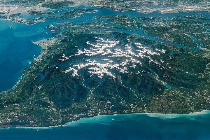
Snow-capped mountains carved by deep river valleys preside over northwestern Washington state. This breathtaking vista, captured by an astronaut aboard the International Space Station on May 6, 2016, offers a dramatic perspective on the Olympic Peninsula, a region renowned for its extraordinary ecological diversity and geological dynamism. The image, a composite of overlapping photographs, showcases a landscape where alpine glaciers, wild coastlines, and temperate rainforests converge, creating a remote bastion of wilderness amidst the bustling population centers of the Pacific Northwest.
A Geological Masterpiece Forged Over Eons
The imposing terrain of the Olympic Mountains is a testament to millions of years of geological activity. The rock that forms these towering peaks has a fascinating origin, primarily originating beneath the surface of the ocean. Between approximately 55 and 15 million years ago, vast layers of basalt from ancient undersea volcanic eruptions, along with accumulating sand and mud carried seaward by rivers, settled on the ocean floor. This sedimentary and volcanic record was then subjected to immense tectonic forces. As the oceanic Juan de Fuca Plate subducted beneath the continental North American Plate, these ocean-floor materials were scraped off, crumpled, and uplifted to create the rugged mountain range, reaching elevations of up to 8,000 feet (2,440 meters) above sea level.
This ongoing geological uplift continues to shape the peninsula, but it is a dynamic balance with the relentless forces of erosion. The region’s abundant rainfall and snowfall at higher elevations provide the crucial ingredient for glacial activity. These ancient ice flows, acting like colossal chisels, carve out the underlying rock, shaping the dramatic valleys seen in the astronaut’s photograph.
The Retreat of Glacial Giants: A Sign of a Changing Climate
While glaciers remain a defining feature of the Olympic Mountains, their future is a subject of increasing concern. Scientific studies have documented a significant retreat and thinning of these ice masses, signaling their vulnerability in a warming climate. A comprehensive study conducted in 2015 identified 255 glaciers and perennial snowfields within the range. Tragically, within the preceding 35 years, 35 glaciers and 16 perennial snowfields had completely disappeared. This trend is not unique to the Olympics, but it serves as a stark visual indicator of global climate change impacts on these sensitive high-altitude environments. The loss of glacial ice has broader implications, affecting water availability downstream, ecosystem stability, and the unique aesthetic appeal of the mountainous landscape.
Rivers of Life: Carving Valleys and Sustaining Ecosystems
Radiating outward from the snow-capped peaks are the deep river valleys that punctuate the mountainous core. Prominent among these, draining west into the Pacific Ocean, are the Hoh, Queets, and Quinault rivers. These verdant valleys are world-renowned for their temperate rainforests, a biome characterized by high rainfall, moderate temperatures, and an astonishing abundance of life. The ancient forest within the Hoh River valley, in particular, has been recognized as one of the most naturally quiet places in the United States, offering an unparalleled auditory escape from human-induced noise.
The Elwha River: A Story of Restoration and Renewal
Flowing northward, the Elwha River holds a rich natural and human history. The valley itself was a site of early Euro-American exploration in the Olympic Peninsula. An expedition sponsored by a Seattle newspaper, which traversed the mountain range from December 1889 to May 1890, journeyed up the Elwha valley, their progress significantly hampered by an unusually harsh and snowy winter.
In the early 20th century, the Elwha River’s potential for economic development was recognized by entrepreneurs. Two dams were constructed on the river to generate hydroelectric power for local industries. However, these structures came at a significant ecological cost, most notably blocking the migration routes of once-abundant salmon and trout populations essential for their spawning grounds.
Recognizing the profound ecological damage, a monumental restoration effort was undertaken. In 2011 and 2014, the Elwha and Glines Canyon dams were removed. At the time, this was the largest dam removal project in the United States. The subsequent years have witnessed a remarkable process of ecological recovery. Fish populations have begun to re-establish themselves, native plant communities are being reseeded, and sediment is being replenished along the riverbanks, slowly returning the Elwha to a more natural, free-flowing state. This ambitious undertaking serves as a powerful case study in ecological restoration and the potential for human intervention to reverse environmental degradation.
A Gateway to the Pacific: The Strait of Juan de Fuca
The Elwha River culminates in a delta that empties into the Strait of Juan de Fuca, the waterway that defines the northern border of the Olympic Peninsula. This strait, stretching between 11 to 17 miles (18 to 27 kilometers) wide, is bisected by the U.S.-Canada border, with Vancouver Island in British Columbia lying to the north. The Strait of Juan de Fuca is a vital conduit, connecting the vast Pacific Ocean with the Strait of Georgia and Puget Sound. Its strategic location makes it a critical shipping lane for major West Coast ports, including Seattle and Tacoma, which can be seen along the upper-right edge of the astronaut’s photograph, representing the confluence of wilderness and human enterprise.
Broader Implications: A Window into Earth’s Systems
The image captured from the International Space Station is more than just a visually stunning photograph; it is a valuable scientific tool. Astronaut photographs, like those of the Olympic Peninsula, provide unique perspectives on Earth’s dynamic systems. They help scientists monitor changes in ice cover, track the extent of vegetation, observe geological formations, and understand the impact of human activities on the environment. The detailed geological history of the Olympic Mountains, coupled with the ongoing ecological processes and the ambitious restoration of the Elwha River, offers a compelling narrative of resilience and change.
The data collected from such observations contributes to a broader understanding of planetary processes, informing climate models, conservation efforts, and our stewardship of natural resources. The visual evidence of glacial retreat, the thriving temperate rainforests, and the successful dam removal project on the Elwha River collectively underscore the interconnectedness of our planet’s ecosystems and the profound impact of both natural forces and human actions. As the Earth continues to evolve, these orbital perspectives offer an invaluable vantage point for appreciating its complexity and beauty, while also highlighting the critical need for continued scientific inquiry and responsible environmental management.
The astronaut photographs, designated ISS047-E-104138 through ISS047-E-104144, were acquired on May 6, 2016, using a Nikon D4 digital camera with a 400-millimeter focal length. These images were provided by the ISS Crew Earth Observations Facility and the Earth Science and Remote Sensing Unit at NASA Johnson Space Center, with contributions from the Expedition 47 crew. The images have undergone processing to enhance contrast and remove lens artifacts, making them freely available to scientists and the public through NASA’s Gateway to Astronaut Photography of Earth.