The immense prehistoric Lake Bonneville, once a body of water rivaling Lake Michigan in size, has left an indelible mark on the Earth’s surface, transforming vast swathes of western Utah and extending into Nevada and Idaho. Its dramatic recession over millennia has exposed expansive, mineral-rich playas and salt flats, creating a unique canvas for human ingenuity, daring exploration, and moments of profound desperation. Today, the ghostly outlines of its former shorelines, etched into the landscape, serve as a testament to the dynamic forces of climate change and geological history.
The Genesis and Cataclysmic Demise of a Superlake
Lake Bonneville began its formation approximately 55,000 years ago, a product of a cooler, wetter climate. A pivotal event in its creation occurred when volcanic eruptions in what is now southeastern Idaho altered the course of the Bear River, channeling its waters into Gem Valley and the basins to the south. For tens of thousands of years, a natural geological dam at Red Rock Pass effectively contained this growing body of freshwater.
The lake’s existence, however, was not to last. Around 18,000 years ago, a dramatic geological event occurred: the dam at Red Rock Pass failed. The breach unleashed a catastrophic flood, one of the largest in North American history, sending an estimated 1,170 cubic miles (4,875 cubic kilometers) of water surging into the Columbia River system. This cataclysmic release caused the lake’s levels to plummet by over 350 feet (105 meters) in a mere six weeks. As the planet subsequently warmed and dried, Lake Bonneville continued its dramatic shrinkage over the following millennia, leaving behind the diminished remnants we recognize today: the Great Salt Lake, Utah Lake, and Sevier Lake.
Echoes of a Lost Lake: Satellite Views and Geological Legacies
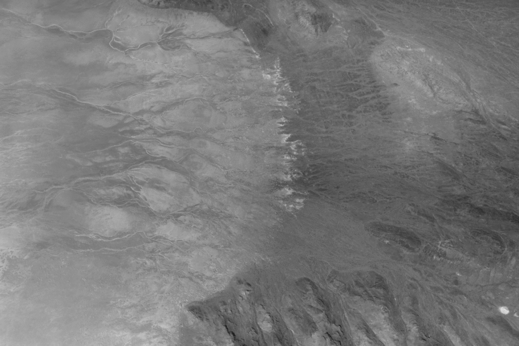
The profound impact of Lake Bonneville is still vividly apparent, even from the vantage point of space. Satellite imagery captured by NASA’s Landsat 8 satellite, equipped with the Operational Land Imager (OLI), reveals the ancient lake’s former boundaries as distinct, bathtub-like rings and wave-cut terraces. These geological markers trace the precise levels at which the lake once lapped against the surrounding land.

The exposed lakebed, a vast expanse of pale, fine-grained clay, marl, and sandy sediment that settled out of the ancient waters, stands in stark contrast to the darker, more rugged, and vegetated terrain of the surrounding mountains. In the deeper depressions of the ancient basin, where residual runoff and groundwater continue to pool, striking deposits of evaporite minerals coat the land. These form expansive salt flats, a direct consequence of water gradually evaporating and leaving behind concentrated mineral brines. Typically composed of halite (common salt), gypsum, and salts containing potassium and magnesium, these flats represent a significant geological and economic resource.
The Economic Allure of the Salt Flats
The mineral wealth of these playas, particularly potash—a crucial component in fertilizers—has long made them a target for mining operations. The presence of rectangular evaporation ponds, visible in contemporary satellite imagery, testifies to the ongoing industrial activity focused on extracting these valuable salts. This economic exploitation highlights how the geological legacy of Lake Bonneville continues to shape human endeavors.
Mountains of Time: The Ancient Bedrock and Volcanic Activity
Rising dramatically from the pale expanse of the salt flats are ancient mountain ranges, including the Silver Island Mountains, Newfoundland Mountains, and the Pilot Range. These rugged terrains are composed of erosion-resistant sedimentary and metasedimentary bedrock, some of which dates back hundreds of millions of years. Interspersed within these ancient sequences are younger igneous and metamorphic rocks, evidence of volcanic intrusions and tectonic activity that occurred as magma forced its way into the Earth’s crust.
Crater Island, a notable feature within this landscape, is itself a geological tapestry. It is composed of sedimentary rocks, including silica-rich sandstones and quartzites formed from ancient ocean sands, alongside intrusions of quartz monzonite and granites. Later periods of crustal stretching sculpted these formations into the fault-block mountains that define the region’s dramatic topography.
"Venus on Earth": A Terrestrial Proving Ground for Interplanetary Exploration
The unique geological formations of the Bonneville basin, particularly Crater Island, have garnered attention not only for their terrestrial significance but also for their utility in testing cutting-edge scientific instruments. In June 2026, NASA scientists and engineers involved in the agency’s DAVINCI mission utilized Crater Island, a location they’ve dubbed "Venus on Earth," as a crucial field-testing site. The objective was to rigorously test the design of cameras and a suite of instruments destined for a pioneering probe that will descend through Venus’s dense atmosphere.
The DAVINCI probe is designed to capture near-infrared images, analyze atmospheric chemistry, and explore the Venusian environment with unprecedented detail during a 60-minute descent. The trials at Crater Island involved suspending the DAVINCI camera system from a helicopter and guiding it towards the surface, mimicking the probe’s descent. This allowed the team to capture hundreds of images of various rock formations, including iron-rich and silica-rich units.
Crucially, by analyzing these images alone, the team successfully generated three-dimensional maps of the area. These maps proved to be consistent with existing geological maps of the region, providing the scientists with high confidence that they will be able to accurately map the geology of Alpha Regio, an analogous mountainous area on Venus that DAVINCI is slated to study. This terrestrial validation underscores the ingenuity required to explore other worlds and the vital role of Earth-based geological analogs.
The Playa as a Stage: Speed Records and Historic Journeys
The remarkably flat and smooth surfaces of the Bonneville Salt Flats have long served as a unique venue for human achievement and, at times, profound hardship. The vast, open expanses have repeatedly set the stage for the pursuit of land speed records, pushing the boundaries of automotive engineering and human daring.
In 1960, Mickey Thompson etched his name in the annals of speed by becoming the first American to break the 400-miles-per-hour (640 kilometers per hour) barrier. He achieved a blistering speed of 406.60 miles per hour (654.36 kilometers per hour) in a highly aerodynamic race car on the Bonneville Salt Flats, earning him the temporary moniker "fastest man on Earth."
More recently, in August 2026, Andy Green, a pioneer in land speed who previously broke the sound barrier on land, set a new record for the fastest land speed achieved by a hydrogen-fueled internal-combustion vehicle. Green reached an astonishing 406.320 miles per hour (653.909 kilometers per hour) in a vehicle dubbed a "rocket car." Notably, this vehicle produced no carbon dioxide emissions, highlighting the growing importance of sustainable propulsion technologies in extreme performance applications.
However, the history of human passage across these ancient lakebeds is not solely one of technological triumph. The desolate beauty of the region also holds somber tales of desperation. In August 1846, members of the ill-fated Donner-Reed Party traversed the southern edge of Crater Island. Seeking a shortcut towards Pilot Peak, they journeyed from Hastings Pass, past Floating Island, and towards Donner Spring. This segment of their journey proved to be an ominous precursor to the tragedies that awaited them. Their heavy wagons, unable to withstand the thin salt crust, broke through and became mired in the underlying mud. This arduous struggle significantly slowed their progress and forced them to abandon several wagons in the harsh desert environment, foreshadowing the severe hardships and eventual starvation that would plague the party.
The Enduring Legacy
The story of Lake Bonneville is a compelling narrative of geological transformation, climatic influence, and human adaptation. From its dramatic formation and cataclysmic demise to its enduring legacy as a site for cutting-edge scientific research and a proving ground for extreme speed, the ancient lakebed continues to inspire awe and underscore the profound interconnectedness of Earth’s natural processes and human history. The ghostly rings on the landscape are not merely geological features; they are echoes of a powerful past that continue to shape our present and inform our future explorations, both on Earth and beyond.