In a groundbreaking study that promises to revolutionize urban environmental monitoring, researchers at the Massachusetts Institute of Technology (MIT) have unveiled a novel method for generating near real-time, high-resolution maps of automobile emissions within cities. Leveraging existing sensor networks and ubiquitous mobile data, this innovative approach offers an unprecedented level of detail, enabling policymakers to develop more targeted and effective transportation and decarbonization strategies. The findings, published in the prestigious journal Nature Sustainability, present a significant leap forward from traditional emissions inventory methods, which often rely on intermittent sampling or less granular citywide data.
The new framework, developed by scientists at the MIT Senseable City Lab, integrates data from a variety of sources, including traffic cameras, anonymized mobile phone location records, and established emissions rate information. This sophisticated fusion of data allows for the extrapolation of highly detailed emission maps, capable of pinpointing pollution hotspots down to the level of a single road segment and specific hour of the day. This granular insight is crucial for understanding the complex interplay between traffic flow, urban infrastructure, and air quality, providing policymakers with actionable intelligence to address public health and environmental concerns.
"Our model, by combining real-time traffic cameras with multiple data sources, allows us to extrapolate very detailed emission maps, down to a single road and hour of the day," explained Paolo Santi, a principal research scientist in the MIT Senseable City Lab and a co-author of the study. "Such detailed information can prove very helpful to support decision-making and understand the effects of traffic and mobility interventions."
The research is part of a broader, ongoing effort by the MIT Senseable City Lab to advance hyperlocal measurements of air quality and other environmental factors. Carlo Ratti, director of the lab, emphasized the transformative potential of this integrated data approach. "By integrating multiple streams of data, we can reach a level of precision that was unthinkable just a few years ago—giving policymakers powerful new tools to understand and protect human health," Ratti stated. This enhanced precision moves beyond broad estimates, allowing for a nuanced understanding of pollution dynamics that can inform interventions with greater confidence.
A key advantage of this new methodology is its inherent privacy protection. The system employs advanced computer vision techniques to recognize different vehicle types without collecting or storing sensitive information such as license plate numbers. This focus on anonymized data ensures that the pursuit of environmental data does not compromise individual privacy. The research effectively harnesses technologies already deployed in urban environments, such as traffic signal cameras, to extract richer data on vehicle movement and its associated pollution.
"The very basic idea is just to estimate traffic emissions using existing data sources in a cost-effective way," said Songhua Hu, a former postdoc in the Senseable City Lab and now an assistant professor at the City University of Hong Kong. Hu is the lead author of the paper, titled "Ubiquitous Data-driven Framework for Traffic Emission Estimation and Policy Evaluation."
Manhattan as a Living Laboratory
To validate their framework, the MIT researchers conducted an extensive study in Manhattan, New York City. They utilized data from 331 traffic cameras strategically positioned at intersections across the borough. These cameras provided visual information about traffic flow and vehicle types. Complementing this visual data were anonymized location records from over 1.75 million mobile phones, offering a comprehensive view of urban mobility patterns.
By applying sophisticated vehicle-recognition algorithms, the research team was able to categorize 12 broad types of automobiles with remarkable accuracy. The study reported a 93 percent success rate in correctly classifying vehicles into their respective categories. Crucially, the imaging data also provided insights into how traffic signal operations influence traffic flow. This is a significant advancement, as stop-and-go traffic patterns, often dictated by signal timing, are major contributors to urban emissions and are frequently overlooked in conventional emissions inventories.
The mobile phone data provided a granular understanding of overall traffic volume and the movement of individual vehicles throughout the city. By combining the insights from traffic cameras and mobile phones with established data on emission rates for different vehicle types, the scholars were able to construct their own detailed emissions estimates for New York City.
"We just need to input all emission-related information based on existing urban data sources, and we can estimate the traffic emissions," Hu explained, highlighting the accessibility of the data inputs.
Simulating Policy Interventions and Their Impact
Beyond simply mapping current emissions, the MIT framework allows researchers to model the potential impact of various policy interventions. By altering input parameters related to traffic patterns or vehicle types, the model can simulate how emissions might change under different hypothetical scenarios.
For instance, the researchers explored the potential environmental benefits of shifting travel demand from private vehicles to public transportation, such as buses. They also modeled the effects of spreading out morning and evening rush hours to reduce the concentration of vehicles on the road at peak times.
A critical aspect of their analysis involved comparing the accuracy of their detailed emissions estimates with those derived from more generalized data. They modeled the effects of substituting fine-grained emissions inputs with citywide averages, a common practice in simpler emissions inventories. The results were striking: these rougher estimates could vary by a staggering range of -49 percent to +25 percent compared to the more finely tuned results. This stark difference underscores how seemingly minor simplifications in data aggregation can introduce substantial errors into emission estimations, potentially leading to misinformed policy decisions.
Congestion Pricing: A Real-World Test Case
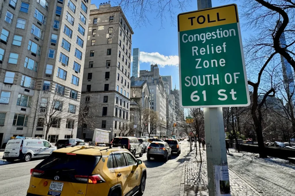
The researchers found a particularly compelling real-world scenario to test their model’s predictive and evaluative capabilities: the implementation of congestion pricing in Manhattan. In January 2025, New York City introduced a congestion pricing program that charges vehicles entering the busiest part of Manhattan, south of 60th Street.
The MIT team analyzed vehicle traffic data at two, four, six, and eight-week intervals following the program’s commencement. Their findings revealed a significant reduction in traffic volume by approximately 10 percent. More importantly, this decrease in traffic was accompanied by a substantial drop in emissions, ranging from 16 to 22 percent.
This observed reduction in emissions aligns closely with findings from a previous study by Cornell University researchers, which reported a 22 percent decrease in fine particulate matter (PM2.5) levels within the congestion pricing zone. The MIT team further observed that the emission reductions were not uniformly distributed across the urban network. Larger declines were noted on some major arterial streets, while the effects outside the immediate pricing zone were more varied.
"We see these kinds of huge changes after the congestion pricing began," Hu remarked. "I think that’s a demonstration that our model can be very helpful if a government really wants to know if a new policy converts into real-world impact." This direct correlation between policy implementation and measurable environmental outcomes validates the efficacy of the MIT framework as a tool for policy evaluation.
Expanding the Data Horizon
The researchers are actively exploring ways to further enhance their framework by incorporating additional data sources. In related work conducted in Amsterdam, the MIT team successfully leveraged dashboard camera footage from vehicles to gather rich information about vehicle movement and traffic dynamics.
"With our model, we can make any camera used in cities, from the hundreds of traffic cameras to the thousands of dash cams, a powerful device to estimate traffic emissions in real-time," said Fabio Duarte, associate director of research and design at the MIT Senseable City Lab, who has been involved in multiple related studies. This suggests a future where a vast array of existing urban cameras can be repurposed to contribute to a real-time, citywide emissions monitoring system.
The research was generously supported by several organizations, including the city of Amsterdam, the AMS Institute, and Abu Dhabi’s Department of Municipalities and Transport. Additional funding was provided by the MIT Senseable City Consortium, a collaborative body comprising Atlas University, the city of Laval, the city of Rio de Janeiro, Consiglio per la Ricerca in Agricoltura e l’Analisi dell’Economia Agraria, the Dubai Future Foundation, FAE Technology, KAIST Center for Advanced Urban Systems, Sondotecnica, Toyota, and Volkswagen Group America.
Broader Implications for Urban Planning and Public Health
The implications of this research extend far beyond academic interest. The ability to generate high-resolution, near real-time emission maps offers city planners and environmental agencies unprecedented tools for understanding and mitigating urban air pollution.
Targeted Interventions: Instead of relying on broad assumptions, policymakers can identify specific streets, intersections, or neighborhoods experiencing the highest levels of pollution. This allows for the implementation of highly targeted interventions, such as optimizing traffic signal timing, rerouting traffic, promoting active transportation in specific areas, or implementing localized low-emission zones.
Policy Effectiveness Measurement: As demonstrated by the congestion pricing study, the framework provides a robust method for evaluating the real-world impact of new policies. This feedback loop is essential for iterative policy improvement, allowing cities to adapt their strategies based on empirical evidence.
Public Health Advocacy: Detailed emission data can serve as a powerful tool for public health advocacy. By visualizing pollution hotspots and their correlation with population density, communities can better understand the health risks they face and advocate for cleaner air policies. This data can also inform urban design, ensuring that new developments are located away from high-pollution areas or are designed with mitigation strategies in mind.
Decarbonization Roadmaps: The framework’s ability to model different scenarios for vehicle fleet changes (e.g., electrification) and mobility patterns provides crucial data for developing effective decarbonization roadmaps. Cities can use this information to set realistic emission reduction targets and identify the most impactful strategies for achieving them.
Economic Considerations: The cost-effectiveness of the methodology, by leveraging existing infrastructure, makes it an attractive option for cities with limited budgets. The ability to accurately assess the return on investment for transportation and environmental initiatives can help justify public spending and encourage further innovation.
The MIT Senseable City Lab’s pioneering work represents a significant advancement in our capacity to monitor and manage urban environmental quality. By transforming ubiquitous data into actionable intelligence, this research paves the way for healthier, more sustainable, and more livable cities for all. The integration of computer vision, mobile sensing, and sophisticated modeling offers a glimpse into the future of urban environmental management, where data-driven insights empower cities to tackle their most pressing challenges.