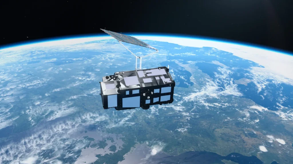
Just two weeks after successfully reaching orbit, Europe’s latest Earth observation satellite, Copernicus Sentinel-3C, has begun transmitting its inaugural scientific data and spectacular imagery. These early transmissions offer an unprecedented glimpse of our planet, showcasing the majestic snow-capped Alps, the vast frozen expanse of the Arctic, and the vibrant turquoise shallows of the Caribbean. However, the mission’s significance extends far beyond its aesthetic appeal. Sentinel-3C’s sophisticated instruments have already commenced vital measurements of ocean heights and the elevation of Greenland’s immense ice sheet, providing an immediate and compelling demonstration of its advanced capabilities in monitoring Earth’s evolving climate.
The initial wave of images and scientific measurements originates from two of Sentinel-3C’s core instruments, both of which have performed exceptionally well during their initial testing phases. This early success brings the satellite closer to its primary mission objectives: to meticulously track environmental changes across the globe with unparalleled precision and scope. As a pivotal component of the European Union’s Copernicus Programme, Europe’s flagship Earth observation initiative, Sentinel-3C is poised to significantly enhance our understanding of the complex systems that govern our planet.
A New Sentinel in the Sky: Enhancing Climate Monitoring Capabilities
Sentinel-3C represents the third spacecraft in the highly successful Sentinel-3 series, a constellation designed to provide continuous and comprehensive data on Earth’s oceans, land, atmosphere, and cryosphere – the frozen regions of our planet. Equipped with identical sets of advanced instruments, these satellites work in concert to create a detailed and dynamic picture of global environmental conditions.
The mission’s reach is extensive. Over the world’s oceans, Sentinel-3 satellites meticulously measure sea surface temperature, ocean color, and sea surface height, in addition to sea ice thickness. These critical observations are instrumental in enabling scientists to investigate the prevalence and impact of marine pollution, track the occurrence and severity of marine heatwaves, and gain a deeper understanding of the intricate changes occurring within ocean systems. The implications for marine ecosystems, fisheries, and coastal communities are profound, offering early warnings and data-driven insights for mitigation and adaptation strategies.
On land, the Sentinel-3 mission yields invaluable information concerning drought conditions, the spread and intensity of wildfires, the health and vitality of vegetation, and the evolving patterns of land use. Furthermore, it diligently measures water levels in rivers and lakes, providing crucial data for water resource management, and tracks subtle yet significant changes in the elevation of polar ice sheets. This comprehensive data collection is not only essential for scientific research but also directly supports operational activities, including weather forecasting, by providing timely observations of environmental conditions. Crucially, these datasets empower researchers to identify long-term trends unequivocally linked to climate change, offering a vital evidence base for policy decisions and international climate agreements.
The European Space Agency (ESA), the driving force behind the Sentinel-3 program, is currently undertaking a rigorous testing and commissioning process for Sentinel-3C. This detailed procedure is expected to span an additional five months, ensuring that all systems are fully operational and calibrated to the highest standards. Despite this ongoing preparation, the satellite’s first two weeks in orbit have already yielded remarkably encouraging results, demonstrating its potential to revolutionize Earth observation.
A Tapestry of Earth: First Images Reveal Global Diversity
The first captivating images transmitted by Sentinel-3C offer a visual testament to its advanced imaging capabilities. One particularly striking image, captured on September 30th by its Ocean and Land Colour Instrument (OLCI), presents a breathtaking natural-color view of Italy and its surrounding seas. This single frame extends from southern Germany, encompassing the entire Italian peninsula, down to Sicily and across the southern Mediterranean Sea. It reveals an extraordinary mosaic of terrestrial and aquatic landscapes, ranging from the imposing grandeur of the Alps to the fertile plains and the deep, captivating blues of the Mediterranean waters.
Within this vivid panorama, the Po Valley stands out as a broad, verdant expanse, signifying the heart of Italy’s agricultural output. Immediately to its north, the majestic Alps rise dramatically, their snow-capped peaks a brilliant white against the surrounding terrain, creating a stark and beautiful contrast. Elsewhere across the Italian landscape, varying shades of green and brown meticulously depict the diversity of vegetation, the intensity of farming activities, and the intricate patterns of land cover.
To the east, the Adriatic Sea forms a clear demarcation between Italy and the partially visible Balkan Peninsula. Along Italy’s eastern coastline, distinct bands of lighter blue water shimmer against the deeper azure of the offshore regions. Scientists hypothesize that these color variations are indicative of sediment carried into the sea by rivers and subsequently redistributed by coastal currents, offering insights into oceanographic processes. On the opposite side of the peninsula, the dark, enigmatic waters of the Tyrrhenian Sea embrace the islands of Sardinia and Sicily. Corsica also makes an appearance within the frame, though its features are partially obscured by cloud cover. Collectively, these contrasting hues of mountains, farmlands, islands, and surrounding seas weave a vivid and comprehensive portrait of Italy as observed from the vantage point of space.
Arctic Sentinel: Monitoring a Warming Frontier
Shifting its gaze far to the north, another image captured by Sentinel-3C on September 30th directs attention to the Canadian Arctic Archipelago, a region situated to the west of Greenland. Here, the landscape presents a dramatically different, yet equally compelling, tableau. Vast expanses of snow and ice blanket many of the islands, interspersed with exposed rock formations, rugged coastlines, and deep fjords that carve intricate patterns across this frozen frontier.
This particular observation was made around the time of year when Arctic sea ice typically reaches its annual minimum extent. Much of the surrounding water appears dark and open, though scattered fragments of floating sea ice remain visible, hinting at the dynamic and rapidly changing nature of this critical ecosystem. These observations are of paramount importance, given that the Arctic is warming at a rate significantly faster than the global average – a phenomenon known as Arctic amplification.
As temperatures continue to rise, glaciers and ice sheets are experiencing accelerated mass loss, and sea ice continues its relentless melt. The disappearance of reflective ice also leads to the exposure of darker ocean water, which absorbs more solar energy, thereby creating a feedback loop that can further accelerate regional warming. Sentinel-3’s suite of instruments observes ice in complementary ways, providing scientists with the tools to better understand the complex and interconnected changes occurring across these vulnerable polar environments. The data will be crucial for predicting future sea-level rise and understanding the global climatic implications of Arctic melt.
Caribbean Colors: Unveiling Underwater Worlds
Sentinel-3C’s third featured image, acquired on September 29th, transports the viewer to an entirely different and equally captivating side of Earth: the vibrant waters of the Caribbean. This scene prominently displays parts of the Caribbean, with Cuba positioned towards the bottom of the frame and the Bahamas stretching towards the top. Surrounding these islands, shallow waters shimmer in brilliant shades of turquoise, creating a striking contrast with the deep, mysterious blue of the surrounding ocean.
These dramatic color differences are not merely visually arresting; they serve as powerful indicators of variations in water depth and the characteristics of the marine environment. The shallower areas, illuminated by sunlight penetrating the clear waters, reveal intricate patterns of coral reefs, sandbanks, and submerged topography. This level of detail is invaluable for marine habitat mapping, coastal management, and understanding the biodiversity of these sensitive ecosystems.
The Caribbean image also serves as a poignant reminder of the significant challenges facing low-lying islands and coastal communities worldwide as global sea levels continue their inexorable rise. One of Sentinel-3C’s most critical instruments, its Synthetic Aperture Radar (SAR) Altimeter, is specifically designed to measure the height of the ocean surface with exceptional precision. By meticulously tracking how this height changes over time, scientists can gain a more accurate understanding of sea-level rise trends and provide crucial data to support efforts aimed at preparing for and mitigating its consequences. The data will be vital for informing infrastructure planning, disaster preparedness, and the long-term viability of coastal settlements.
Precision Measurements: Validating Performance
Beyond its visually stunning photographic capabilities, Sentinel-3C has already begun to demonstrate its prowess in gathering precise scientific measurements. Its radar altimeter has successfully collected sea surface height data across significant portions of the Atlantic Ocean and the Mediterranean Sea. Researchers have meticulously compared these early observations with existing multimission sea-level anomaly data, which aggregate measurements from multiple satellites, as provided by the Copernicus Marine Service.
The initial results exhibit a commendable agreement with established measurements, providing strong validation that the new altimeter is operating precisely as expected. Once Sentinel-3C completes its commissioning phase, it will seamlessly integrate into the global sea-level monitoring network, working alongside established satellite missions such as Copernicus Sentinel-6 and the Jason series. These long-running, high-precision observations are indispensable for accurately understanding the rate at which the world’s oceans are rising, a critical indicator of climate change.
Precise satellite measurements have already established that global sea levels have increased by an average of 3.64 millimeters per year since 1999. Furthermore, the rate of sea-level rise has been accelerating, underscoring the increasing importance of continuous and enhanced monitoring. Sentinel-3C’s altimeter will contribute more than just ocean measurements; it will also observe changes in the height of rivers, lakes, sea ice, and land ice, thereby complementing future observations from the forthcoming Copernicus CRISTAL mission, which is dedicated to monitoring the cryosphere and its interactions with the climate system.
Tracking Ice Sheets: A Cryospheric Sentinel
Some of the most encouraging early results from Sentinel-3C emanate from the vast and critically important region of Greenland. Between September 30th and October 4th, the satellite meticulously collected measurements of the Greenland Ice Sheet’s surface elevation. An accompanying animation vividly illustrates the precise tracks of these observations across the enormous, ice-covered landscape, offering a dynamic visualization of the satellite’s coverage.
When scientists compared these newly acquired measurements with a reference digital elevation model – a detailed three-dimensional representation of the ice sheet’s surface – the satellite’s observations closely matched the existing, highly accurate data. This remarkable agreement provides further compelling evidence that the radar altimeter is functioning optimally and delivering reliable data.
Accurately tracking the elevation of ice sheets is of paramount importance as the planet continues to warm. Greenland and Antarctica together hold colossal quantities of frozen water, and any changes in the stability and mass of their respective ice sheets can have profound and far-reaching consequences for global sea levels. Ice loss from these polar regions is already a significant contributor to ongoing sea-level rise. By repeatedly measuring the height of their surfaces, satellites like Sentinel-3C enable scientists to monitor these changes over time and significantly improve the accuracy of predictions regarding future sea-level rise. These predictions are vital for coastal planning, infrastructure development, and the long-term adaptation strategies required to address the impacts of a warming world.
The Road Ahead: Continued Commissioning and Global Impact
Although Sentinel-3C is still in its nascent stages of testing and calibration, its initial observations represent a significant stride towards its full scientific operational capacity. The satellite’s Ocean and Land Colour Instrument has already delivered remarkably detailed images of diverse landscapes and coastlines, while its radar altimeter has produced highly promising measurements of both ocean and ice sheet elevations.
Another crucial milestone is rapidly approaching: the mission is preparing to release the first observations from its Sea and Land Surface Temperature Radiometer (SLSTR). This instrument is specifically designed to measure the temperature of Earth’s land and ocean surfaces with exceptional accuracy, providing critical data for climate modeling, weather forecasting, and the study of heat distribution across the planet.
Sentinel-3C is an integral part of Copernicus, the Earth observation component of the European Union’s ambitious Space Programme. The European Space Agency (ESA) holds the responsibility for the development and implementation of the Sentinel-3 satellites and their initial operation through the commissioning period. Following this phase, the Sentinel-3 mission enters a joint management structure, overseen by both ESA and the European Organisation for the Exploitation of Meteorological Satellites (Eumetsat).
Eumetsat assumes responsibility for the routine operational management of the satellites and the supply of marine and atmospheric observations. Concurrently, ESA continues to provide data covering land, the cryosphere, inland waters, and atmospheric products that are processed after acquisition. This collaborative framework ensures that the invaluable data generated by Sentinel-3 is made readily available to Copernicus services and a wide array of users across the globe.
With its first images and scientific measurements already underscoring its promising performance, Sentinel-3C is firmly on track to become another indispensable tool for observing Earth’s oceans, landscapes, ice sheets, and atmosphere. In an era of unprecedented planetary change, this advanced satellite will play a critical role in monitoring, understanding, and ultimately responding to the evolving challenges facing our planet.