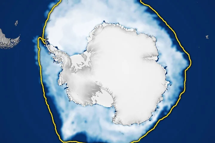
The Antarctic region, a vast continent encased by the Southern Ocean, has historically presented a different sea ice dynamic compared to its Arctic counterpart, which is an ocean basin surrounded by land. This geographical distinction allows Antarctic sea ice more room to expand during the winter months. However, its proximity to warmer latitudes also means that a significant portion of this ice succumbs to melting during the summer. Typically, Antarctic sea ice reaches its annual peak in September, coinciding with the end of the Southern Hemisphere’s winter, and then recedes to its minimum extent in February. In 2026, this pattern continued, with Antarctic sea ice likely reaching its annual maximum extent on September 14, covering an estimated 17.59 million square kilometers (6.79 million square miles). This figure, according to data from NASA and the National Snow and Ice Data Center (NSIDC), represents the third-lowest maximum on record, adding to a growing trend of declining sea ice in the region.
A Shift in Antarctic Sea Ice Trends
For several decades, from 1979 until 2014, Antarctic sea ice exhibited a modest but consistent increase, growing by approximately 1 percent per decade. This period was marked by notable milestones, with satellites observing new record highs for winter sea ice extent for three consecutive years, from 2012 to 2014. These increases occurred against a backdrop of a steep decline in Arctic sea ice, leading to considerable scientific discussion about the potential drivers and implications of these divergent trends. Scientists were cautious in interpreting whether these Antarctic gains signaled a truly meaningful long-term change or were merely part of natural year-to-year variability, which is inherently significant around Antarctica.
However, this upward trajectory came to an abrupt halt in 2015. The year 2016 marked a turning point, ushering in a period of significant decreases in Antarctic sea ice. While there have been occasional years with minor rebounds in ice coverage, the overarching trend since 2016 has been one of sea ice levels remaining consistently below the long-term average. The year 2023 proved particularly stark, witnessing both the record-low minimum and record-low maximum sea ice extents. The 2026 maximum extent, while not a new record low, reinforces the concern that the recent declines are not merely statistical fluctuations but may represent a fundamental shift in the Antarctic sea ice regime.
Monitoring the Frozen Continent: A History of Satellite Observation
The ability to track these changes relies heavily on sophisticated satellite technology. Scientists employ passive microwave sensors on orbiting satellites to measure the microwave energy that the Earth naturally emits. Sea ice, due to its composition, emits more of this energy than open water, making it readily distinguishable in microwave imagery. A significant advantage of this technology is its ability to penetrate cloud cover, allowing for regular and consistent observation of sea ice extent, irrespective of prevailing weather conditions.
The continuous record of Antarctic sea ice observations began in late 1978 with data from NASA’s Nimbus-7 satellite. This was followed by data from the Defense Meteorological Satellite Program (DMSP) satellites, which commenced in 1987. NASA’s Aqua satellite contributed valuable observations between 2002 and 2011. More recently, in 2025, scientists began integrating data from the Japan Aerospace Exploration Agency’s (JAXA) GCOM-W satellite, ensuring an unbroken and increasingly refined understanding of sea ice dynamics. This long-term, multi-satellite approach provides a robust dataset for analyzing trends and anomalies.
Understanding Sea Ice Extent: Methodology and Metrics
To quantify sea ice extent, scientists utilize a specific methodology. They define an area as being covered by sea ice if its concentration is at least 15 percent. This threshold is a widely accepted standard in the scientific community for counting an area as ice-covered in satellite data. The total area encompassing these regions is then referred to as the "sea ice extent." The maps accompanying this analysis, which illustrate the average concentration of Antarctic sea ice for September (peak season) and the following February (minimum season) from 1990 to 2026, provide a visual representation of this phenomenon. Areas depicted in opaque white signify the highest ice concentrations, while dark blue areas represent open water.
Expert Analysis and Potential Implications
Dr. Walt Meier, a senior research scientist at the NSIDC, commented on the significance of these findings. "While we’ve seen year-to-year variability in Antarctic sea ice for decades, the sustained period of lower-than-average extents since 2016 is a cause for concern," Dr. Meier stated. "The 2026 maximum extent, while not a record low, places us firmly in the category of record-low maximums. It’s crucial to continue monitoring this trend to understand if we are witnessing a fundamental shift in the Antarctic system."
The implications of declining Antarctic sea ice are multifaceted. Sea ice plays a vital role in regulating Earth’s climate by reflecting solar radiation back into space, a phenomenon known as the albedo effect. A reduction in sea ice cover means less solar radiation is reflected, leading to increased absorption of heat by the ocean, which can further accelerate melting and warming.
Furthermore, Antarctic sea ice is a critical habitat for numerous species, including penguins, seals, and krill, which form the base of the Antarctic food web. Changes in the extent and thickness of sea ice can disrupt breeding patterns, foraging behaviors, and the overall health of these ecosystems. For instance, a reduction in sea ice can impact the availability of krill, which rely on algae that grow on the underside of the ice for sustenance.
The continent’s ice shelves, which are floating extensions of the land-based ice sheet, are also influenced by sea ice. While sea ice itself does not directly contribute to sea-level rise when it melts (as it is already floating), its presence can help to buttress ice shelves. A decrease in sea ice could potentially lead to increased instability of these ice shelves, accelerating the flow of land ice into the ocean and thus contributing to global sea-level rise.
Future Research and Outlook
Scientists are actively engaged in research to disentangle the complex factors contributing to the observed changes in Antarctic sea ice. These factors include variations in atmospheric circulation patterns, ocean currents, and the influence of greenhouse gas emissions. Understanding the relative contributions of natural variability versus anthropogenic climate change is paramount for accurate climate projections.
The ongoing observation of Antarctic sea ice extent remains a high priority for the international scientific community. Continued data collection, coupled with advanced modeling techniques, will be essential to determine whether the current period of reduced sea ice coverage represents a long-term, persistent trend or a temporary deviation from historical patterns. The findings from 2026 underscore the urgency of this research and highlight the dynamic and evolving nature of Earth’s polar regions in the face of a changing climate. The data collected by NASA, NSIDC, and their international partners will be instrumental in informing future climate policies and conservation efforts aimed at protecting this vital region.