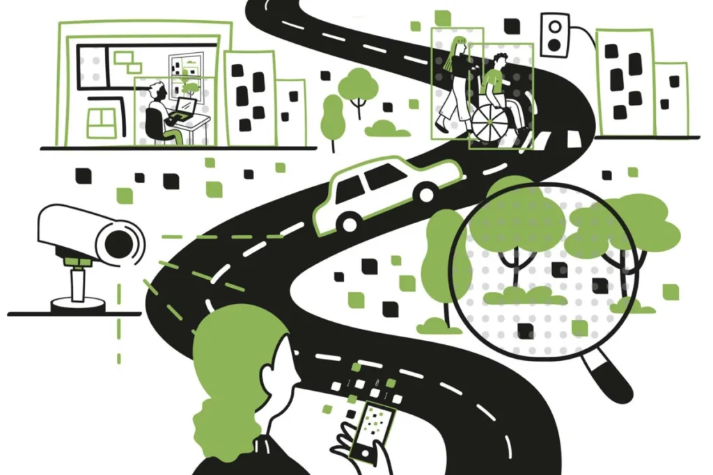
A groundbreaking study published a few months ago by researchers at the MIT Senseable City Lab has unveiled novel methodologies for understanding urban environments, particularly concerning the pervasive issue of traffic emissions. This research, which leverages machine learning and advanced visual artificial intelligence, has the potential to revolutionize how cities monitor and manage their environmental impact. By analyzing footage from 331 traffic cameras across New York City, the MIT team successfully identified specific vehicle types and subsequently estimated the precise emissions generated by each. This innovative approach promises an unprecedented level of accuracy and scale in environmental monitoring, offering urban planners powerful new insights into the complexities of city life.
The implications of such visual AI techniques extend far beyond emission tracking. Urban planners can now pose and answer a myriad of critical questions with greater precision. For instance, understanding the root causes of traffic congestion, identifying the most hazardous elements within complex intersections, or determining which public spaces, such as plazas and parks, attract the highest levels of human activity are all becoming more attainable objectives. As the volume of visual data generated across cities continues to escalate, so too does the potential for deeper understanding. However, this surge in data also amplifies concerns regarding privacy and the ethical considerations of fairness in the application of these technologies.
Fabio Duarte, an MIT researcher and co-author of the recently published book "How AI Sees the City: Urban Visual Intelligence," emphasizes the transformative power of this technological shift. "We can treat these digital images as data and quantify features of the city," Duarte explains. "With computer vision techniques, each image is a dataset." He also stresses the critical need for caution, acknowledging the inherent responsibilities that accompany such potent tools.
Martina Mazzarello, another MIT scholar and co-author of the new book, echoes this sentiment, highlighting the long-standing human inclination to observe and interpret urban landscapes. "Everybody has been observing the urban environment and trying to get some insight," Mazzarello notes. "But what if we can do that at a large scale and get some insight everywhere?" This question lies at the heart of their research, pushing the boundaries of what is visually observable and analytically derivable within urban contexts.
The scholars delve into these complex themes in their new book, "How AI Sees the City: Urban Visual Intelligence," published this month by Routledge. The book is a collaborative effort by Duarte, a principal research scientist and associate director at the MIT Senseable City Lab; Mazzarello, a research scientist and lead of MIT Senseable City Lab global initiatives; Carlo Ratti, a professor of the practice and founder and director of the MIT Senseable City Lab; and Fan Zhang, an assistant professor at the Institute of Remote Sensing and GIS at Peking University.
Carlo Ratti draws a direct line between contemporary AI capabilities and the foundational work of influential urbanists. "Great urbanists such as Kevin Lynch and William H. Whyte showed us the extraordinary value of ‘looking’ at the city," Ratti states, referencing seminal thinkers whose work is explored within the book. "Today, visual AI gives us new ways to build on that tradition – allowing us to observe cities at a scale and with a level of detail that was previously impossible." This historical perspective underscores that while the tools are new, the fundamental human endeavor to understand and improve cities remains constant.
A New Tool in a Long Tradition of Urban Observation
The insights presented in "How AI Sees the City" are rooted in the ongoing work of the MIT Senseable City Lab, established in 2004 with the mission of using data to deepen the understanding of urban dynamics. The authors meticulously trace the historical evolution of visual representations that have shaped urban thought, from ancient Roman marble maps to the advent of photography, which profoundly influenced perceptions of urban transformation, such as Baron Haussmann’s radical redesign of Paris or the stark realities of 19th-century tenement life in New York City’s Lower East Side.
More recently, scholars like Kevin Lynch, a former MIT professor whose seminal 1960 book "The Image of the City" profoundly impacted urban studies, and William H. Whyte, a sociologist renowned for his meticulous examination of public spaces, have employed visual analysis to dissect urban form. By situating visual AI within this historical continuum, the authors position it not as a replacement for human observation and intention, but as a powerful extension. They argue that AI, while potent, should primarily serve human goals in the ongoing process of designing and refining urban environments.
Duarte elaborates on this connection, stating, "Kevin Lynch at MIT was only using paper and pen. We can now scale up what he was doing, with visual AI, while also looking at many different dimensions of cities." This advancement allows for a far more comprehensive and granular analysis than was previously conceivable, enabling the study of multiple facets of urban life simultaneously.
The potential applications of visual AI in urban planning are extensive. Beyond emission monitoring and traffic flow analysis, these technologies can enhance understanding of public safety, provide detailed street-level imagery of pedestrian activity, and offer new perspectives on the design and utilization of sidewalks. The book also explores the nuanced relationship between urban greenery and well-being. While satellite imagery can quantify the extent of tree cover and green spaces, the ubiquity of personal devices and other image sources allows for a more intimate understanding of how frequently residents actually encounter and benefit from greenery in their daily lives, a factor directly linked to reported levels of wellness.
Fan Zhang articulates the core promise of this technology: "The real promise of visual AI is not simply that computers can look at millions of images. It is that we can connect what is visible in those images – streets, buildings, greenery, traffic, public space – with larger questions about how cities function and how people experience them." This integration of visual data with socio-economic and experiential factors represents a significant leap forward in urban analysis.
The capabilities of AI-driven image recognition are even extending to the analysis of urban interiors. A recent study from the Senseable City Lab, analyzing images from 400,000 Airbnb listings globally, revealed that interior design styles are not becoming universally homogenized, but rather continue to exhibit significant regional variations. This demonstrates the power of AI to discern subtle yet meaningful patterns in diverse datasets.
"No matter what it is, we can learn from what we can see and then use it as urban designers, planners, policymakers, and citizens," Mazzarello concludes. "It can be our eyes, or cameras with computers, but in the end it’s the same methodology, and now we are trying to optimize the ways we can use these tools." This perspective frames visual AI as an indispensable tool for informed decision-making and effective urban stewardship.
Promise and Pitfalls: Navigating the Ethical Landscape
While the potential benefits of visual AI in urban studies are undeniably vast, the authors of "How AI Sees the City" are acutely aware of the inherent pitfalls. The book meticulously outlines multiple concerns, chief among them being the pervasive nature of visual surveillance and the risk of AI systems perpetuating and amplifying existing societal biases.
The widespread deployment of cameras in urban environments inevitably raises alarms about surveillance. London, an early adopter of Closed-Circuit Television (CCTV), reportedly has approximately 210 cameras per square mile. However, eight of the world’s ten most camera-dense cities are located in China, with Shanghai alone boasting over 5,000 cameras per square mile. Such extensive surveillance practices have ignited considerable controversy globally, and debates surrounding the use of traffic cameras are gaining traction in the United States as well.
In assessing the potential safety advantages of intensive video recording, the authors critically note, "the benefits must be weighed against the significant erosion of personal freedom and the potential for abuse inherent in a system of constant monitoring." This statement highlights the delicate balance between security objectives and the fundamental right to privacy.
Furthermore, AI systems are susceptible to reinforcing social biases. If AI models are predominantly trained on data representing majority populations, their analysis and subsequent outputs may not accurately reflect or fairly evaluate minority groups. This can lead to the creation of data that entrenems pre-existing perceptions rather than capturing the full spectrum of urban realities.
"We need to teach AI to see, and depending on how you teach it, it will see what is embedded in the culture," Duarte cautions. "AI is not neutral." This underscores the crucial responsibility of developers and researchers to ensure that AI systems are trained on diverse and representative datasets, and that their algorithms are designed to mitigate bias.
Mazzarello offers a nuanced perspective on this challenge: "our eyes are not neutral, either. Every tool has to be guided in the right way, and trained in the best way." This analogy suggests that human perception is also inherently subjective, and the goal with AI should be to cultivate a more objective and equitable form of observation through careful training and ethical deployment.
The book has garnered positive reception from other scholars in the field. Michael Batty of University College London has described it as a "fascinating book" that "shows how we are beginning to interpret the world of urban design, suggesting ways in which we might improve design using urban analytics, AI and large language models." This endorsement highlights the book’s significant contribution to advancing the discourse on urban design and the role of emerging technologies.
Ultimately, the authors firmly believe in the immense value of deploying visual AI for enhanced urban understanding and improvement. They advocate for a measured and critical approach, emphasizing that progress is achievable through careful consideration and innovative thinking. Their concluding message in the book resonates with this sentiment: "We should explore this wisely, critically, and creatively." This call to action encourages a forward-looking perspective that embraces the potential of visual AI while remaining vigilant about its ethical implications, ensuring that these powerful tools are harnessed for the betterment of cities and the well-being of their inhabitants.